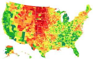
I stopped the development of my applet MAPresso.
The increasing problems with applets in browsers make it no longer interesting to work in this area. At the moment, I think that solutions based on JavaScript, specially d3.js, give much better results. I'll try to transform some ideas of my applet to JavaScript.
First tests with d3.js are promising.
- A comparison to other classification models.
- Two very compact d3.js examples with the typical color schemes of MAPresso


MAPresso is was a free Java applet for unclassed choropleth maps and cartograms.

Unclassed Maps
Avoiding the problem of fixing (optimal or suitable) class limits, this approach uses a continuous-tone scheme. With the possible exception of extreme values which can fall into two "classes" on either side of the value range, each region has its own specific color value. In the case where an important threshold exists (e.g. 50% "yes" in vote results) there can be set a class boundary for two separate color transitions.
Bi- and Trivariate Maps
Two and three variables can be visualized simultaneously as bivariate or trivariate choropleth maps using a special color scheme, there is an option for maps with nominal data.
Area Cartograms
In addition, the areas can be distorted to create a continuous area cartogram. It's an implementation of the algorithm proposed by Dougenik, Chrisman and Niemeyer (1985).
Circle Cartograms
Data values can be also visualized as circle cartograms (Dorling 1996), cf. Dorling applet.
Thematic Generalization
An additional feature allows a thematic generalization of the map by a simple polygon filter (see Herzog, 1995). The implemented filter is based on a Markov process.
Data
Data values can be provided as text files. In addition, the user can enter his own data via the clipboard into a text field.
Geometry: Polygons in psc-format (can be converted from ArcGIS shapefiles), circle data as text files. Some data sets are available.
Output: An output as a file is not in the focus of the applet, there is a provisional possibility to produce an encapsulated PostScript file (EPS). The distorted geometry of a cartogram process can be exported in ArcGIS generate format.
Availability
MAPresso is free. Downloads.
|| Next page: Quickstart
Links
Climate Diagrams
Gallery
Gallery Solitaire
Download iPhone App or
play the game online!
News
Recently updated
- Gallery Solitaire
Updated: 01.04.2015 - About, Contact
Updated: 18.09.2013 - Message Codes
Updated: 18.09.2013 - Varia
Updated: 18.09.2013